

Critical weather conditions forecast for Thursday, May 29
MEXICO CITY – The National Meteorological Service (SMN) has issued a weather alert for heavy rains and strong wind gusts expected to affect more than 20 Mexican states due to the movement of Tropical Depression Uno-E, located south-southwest of Guerrero. Its extensive cloud bands will bring torrential downpours, electrical storms, and possible hail across various regions.
Areas most affected overnight Wednesday into early Thursday include Michoacán, Guerrero, and Puebla, with intense rainfall expected. Querétaro, Hidalgo, Tlaxcala, Estado de México, and Morelos are forecast to receive very heavy rain, while Jalisco, Colima, Guanajuato, and Mexico City can expect heavy showers, and Nayarit may experience isolated rainfall. Winds of 25 to 40 mph (40–60 km/h) and waves reaching up to 10 feet (3 meters) are expected along the coasts of Colima, Michoacán, Guerrero, and Jalisco.
Compounding effects of low-pressure systems
Across the north, central, and southeastern regions of the country, low-pressure channels, combined with moist, warm air from the Pacific Ocean, Gulf of Mexico, and Caribbean Sea, will result in intense rain in Tamaulipas and very heavy rain in Coahuila, Nuevo León, San Luis Potosí, and Chiapas. Showers and thunderstorms are also forecast for Chihuahua, Durango, Zacatecas, Aguascalientes, Tabasco, and Quintana Roo, with light isolated rainfall in Campeche and Yucatán.
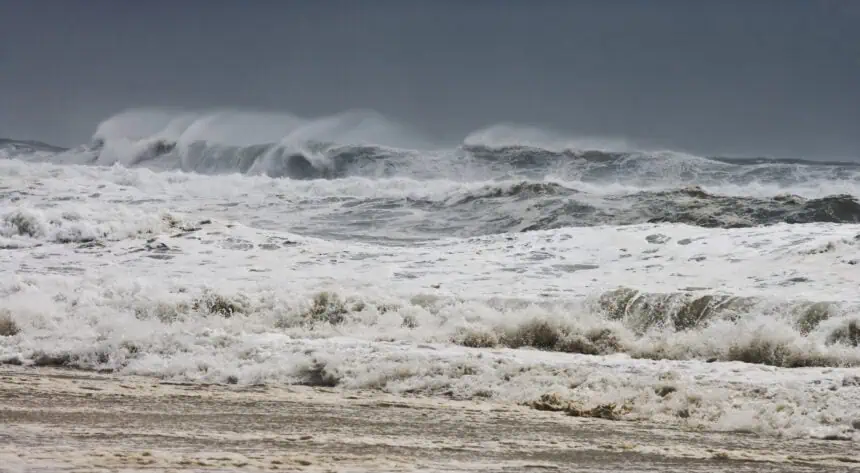
Tropical cyclone to impact Pacific coast
On Thursday, the tropical cyclone is expected to move along the coasts of Michoacán, Colima, and Jalisco, bringing very heavy rain to Guerrero, and heavy rainfall to Jalisco, Colima, and Michoacán. Wind gusts could reach up to 45 mph (70 km/h), accompanied by elevated wave activity up to 10 feet (3 meters).
Forecast for the Valley of Mexico
In the Valley of Mexico, skies will be partly to mostly cloudy, with morning fog patches and afternoon thunderstorms in Mexico City and the State of Mexico, possibly accompanied by hail. Minimum temperatures in Mexico City will range from 55 to 59 °F (13–15 °C), with highs between 73 and 77 °F (23–25 °C). In Toluca, lows will be 50 to 54 °F (10–12 °C) and highs 66 to 70 °F (19–21 °C). Winds will be variable, with gusts up to 28 mph (45 km/h).
Weather risks and potential hazards
Heavy to intense rainfall could lead to flooding, landslides, and overflowing rivers and streams. Strong wind gusts across Baja California, Sonora, Sinaloa, Durango, Jalisco, Chihuahua, Coahuila, Yucatán, Campeche, and Quintana Roo pose an elevated wildfire risk. There’s also potential for falling trees and billboards.
Rainfall forecast for Thursday, May 29
Intense rain (3–6 inches / 75–150 mm): Hidalgo
Very heavy rain (2–3 inches / 50–75 mm): Tlaxcala, Puebla, Guerrero, Veracruz, Oaxaca, Chiapas
Heavy rain (1–2 inches / 25–50 mm): Jalisco, Colima, Michoacán, Chihuahua, Durango, Coahuila, Nuevo León, Tamaulipas, San Luis Potosí, Guanajuato, Querétaro, Estado de México, Mexico City, Morelos
Showers (0.2–1 inch / 5–25 mm): Zacatecas, Aguascalientes, Nayarit, Tabasco, Quintana Roo
Isolated rain (less than 0.2 inch / <5 mm): Baja California, Sinaloa, Campeche, Yucatán
Maximum temperature forecast for Thursday, May 29
104–113 °F (40–45 °C): Sonora, Chihuahua, Coahuila, Durango, Sinaloa, Nayarit, Colima, Michoacán, Guerrero, Tabasco, Campeche, Yucatán
95–104 °F (35–40 °C): Baja California, Baja California Sur, Jalisco, Nuevo León, Tamaulipas, San Luis Potosí, Zacatecas, Guanajuato, Querétaro, Hidalgo, Puebla, Morelos, Oaxaca, Chiapas, Veracruz, Quintana Roo
86–95 °F (30–35 °C): Aguascalientes and southwestern Estado de México
Wind and surf forecast for Thursday, May 29
Winds of 12 to 18 mph (20–30 km/h) with gusts up to 45 mph (70 km/h): Chihuahua, Durango, Coahuila, Jalisco (coast), Colima, Michoacán (coast)
Winds of 6 to 12 mph (10–20 km/h) with gusts of 25 to 37 mph (40–60 km/h): Nuevo León, Tamaulipas, Zacatecas, Tabasco, Campeche, Yucatán, Quintana Roo
Blowing dust possible in: Baja California, Baja California Sur, Sonora, Sinaloa, Nayarit
Waves 6–10 feet (2–3 meters): coasts of Jalisco, Colima, Michoacán
Waves 3–6 feet (1–2 meters): coasts of Guerrero, Oaxaca, Chiapas


