

⛈️ Severe thunderstorms expected in Northern California on Tuesday
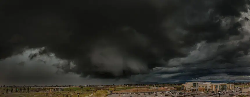
A quick-moving shortwave will sweep across Northern California this Tuesday, June 10, triggering the formation of scattered thunderstorms during the early to midafternoon. These storms are forecast to develop primarily over the mountainous regions from Lassen National Park to Mount Shasta, before possibly drifting into Shasta Valley and the northern Sacramento Valley by evening.
The Storm Prediction Center has issued a marginal risk alert (Level 1 out of 5) for severe weather, particularly across Siskiyou, Shasta and Modoc counties, with the highest potential for damaging wind gusts and hail up to 1 inch in diameter (quarter-size, ~2.5 cm).
🌩️ Thunderstorm details and severe threats
These thunderstorms, initiated by the shortwave disturbance in the jet stream, could bring cloud-to-ground lightning, gusts exceeding 58 mph (93 km/h) and a 15% chance of hail up to 1 inch (2.5 cm) in diameter. The greatest threat is expected in terrain-funneled zones, like narrow canyons, where downdraft enhancement may increase the severity of wind events, according to Chris Johnston, meteorologist at the National Weather Service in Reno.
While rain will initially accompany these storms, speeding storm motion in the evening hours may elevate the risk of lightning-induced wildfires, particularly as vegetation begins to dry, although wildfire fuel levels remain below typical midsummer thresholds.
🌧️ Regional weather breakdown across Northern California
San Francisco and the Bay Area will experience very little direct impact from the thunderstorms. However, persistent marine cloud cover, drizzle, and fog are expected to dominate Tuesday’s weather.
San Francisco: Morning overcast skies and drizzle will affect neighborhoods such as Richmond, Sunset, Presidio and Marina, with highs only reaching the upper 50s°F (around 14–15°C). The Mission District may briefly climb into the low 60s°F (16–17°C). Evening gusts of 15–25 mph (24–40 km/h) and overnight fog are anticipated.
North Bay: Afternoon sun will replace morning clouds in Wine Country, except near the Petaluma Gap. Coastal areas will hover near 60°F (15–16°C), rising to mid-70s°F (23–24°C) inland and possibly reaching 90°F (32°C) in Vacaville.
East Bay: Areas from Richmond to Hayward will begin the day under low clouds, clearing inland by midmorning. Highs will range from low 60s°F (16°C) in Alameda to low 80s°F (27°C) in inland valleys. Breezy winds are forecast in the afternoon.
Pacific Coast and Peninsula: The marine layer will reinforce cloudy and cool conditions, especially near San Francisco International Airport, with highs between low 60s°F (16°C) along the coast and mid-70s°F (24°C) in Redwood City.
South Bay and Santa Cruz: A classic summer pattern continues. Morning fog will give way to sunshine and highs in the mid-80s°F (29°C) in the Santa Clara Valley, with Santa Cruz reaching the 60s°F (16–18°C) at the beaches and mid-80s°F (29°C) in the mountains.
🌄 Weather outlook for midweek
By Wednesday, the shortwave responsible for Tuesday’s storms will shift eastward into eastern Oregon and Idaho, bringing storm chances there. California’s mountains are expected to enjoy a temporary break from thunderstorm activity through the end of the week, while drier air may cause patchier fog along the Bay Area coast, potentially offering brief sunny intervals.


