

Tropical storm Andrea, officially named on Tuesday, June 24, has become the first named storm of the 2025 Atlantic hurricane season, according to the National Hurricane Center (NHC). As of this morning in New York, the system is spinning across the open waters of the Atlantic Ocean, more than 1,200 miles west of the Azores, and not posing any direct threat to the mainland United States.
With sustained winds near 40 mph (about 65 km/h) and higher gusts, Andrea is moving east-northeast at 17 mph (27 km/h). Forecasters expect the storm to weaken by tonight, with complete dissipation likely by Wednesday night, June 25. The system is heading into cooler waters and encountering unfavorable upper-level winds, which will hinder its ability to remain organized.
A late start for the 2025 Atlantic hurricane season
Although the Atlantic hurricane season officially begins on June 1 and runs through November 30, Andrea’s formation on June 24 is slightly later than the average first storm date of June 20. According to Phil Klotzbach, senior research scientist at Colorado State University, this is a modest delay in what’s projected to be an active and potentially dangerous season.
Atmospheric activity over the eastern Pacific has been influencing wind patterns that temporarily suppress storm formation in the Atlantic. According to the Climate Prediction Center, this trend could persist into early July, but is not expected to hold off the season’s peak, which typically occurs around September 10, with most storms forming between mid-August and mid-October.
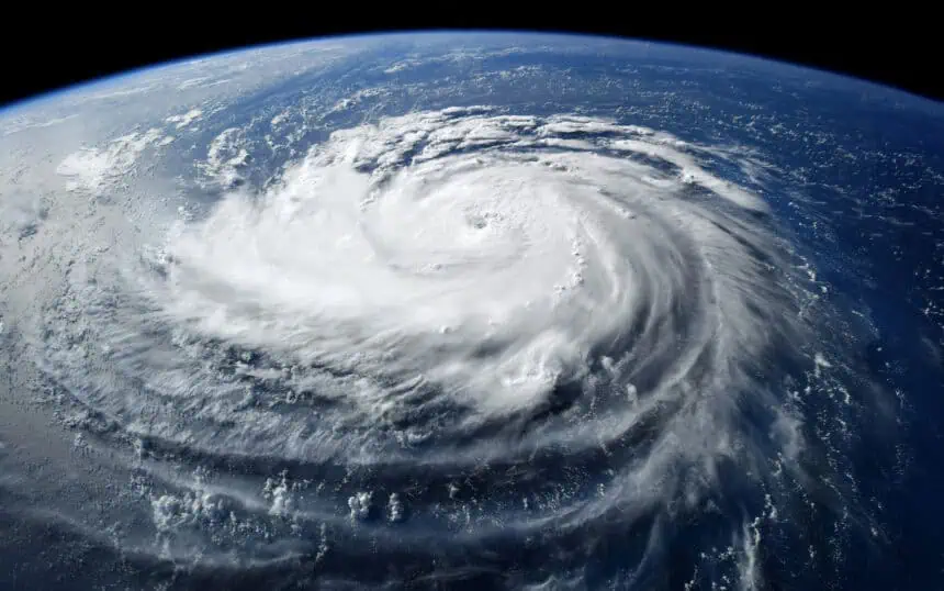
Tracking tropical storm Andrea’s path
The forecast cone for Andrea shows its likely path, which remains confined to the open Atlantic. However, it’s important to note that this cone represents only the probable track of the storm’s center, not the entire storm system. The National Hurricane Center indicates there’s about a 33% chance that the storm’s core could move outside the predicted cone.
Spaghetti models, which show a range of computer-generated forecasts, are also being used. While dozens of models exist, the NHC relies on the four or five most reliable ones to form its official outlook.
Eastern Pacific: another system under close watch
While Andrea drifts through the Atlantic, meteorologists are also closely monitoring a broad area of low pressure in the eastern Pacific, located several hundred miles south of the coast of Guatemala. This disturbance is producing disorganized showers and thunderstorms, but the environment is becoming increasingly favorable for its development.
According to today’s update, there is a 70% chance that this system could become a tropical depression by the weekend, as it moves slowly west-northwestward, parallel to the southern coast of Mexico. This area continues to be closely analyzed by the NHC’s Pacific storm team using similar forecast tracking tools.
Pacific forecast cone under review
The Pacific storm cone serves the same purpose as its Atlantic counterpart: showing the most likely path of the storm’s center, not the full scope of its winds and rainbands. And just like in the Atlantic, there’s a one-in-three chance the storm center could veer outside the cone’s predicted route, making continuous updates essential.


