
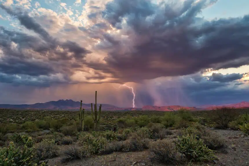

PHOENIX, Arizona — After enduring more than a week of blistering heat, many Arizonans are casting hopeful eyes toward the horizon and asking the same question: Where’s the monsoon?
Though the season officially kicked off on June 15, the signature sounds and sights of Arizona’s summer rains—booming thunder, flash downpours, and streaks of lightning—have been noticeably absent across the state.
There was a brief rain event in Phoenix earlier this month, but since then, a stubborn high-pressure system has taken hold over the region, locking in dry, oppressive air and blocking monsoonal moisture from moving in.
On July 9, Phoenix hit a brutal 118°F (47.8°C)—a record-breaking temperature that served as a reminder of just how powerful this heat dome has become. There is, however, a glimmer of hope. While the monsoon is off to a sluggish start, forecasters say it’s slowly beginning to stir, though it’s following nature’s timing, not the calendar.
Monsoon delayed by high pressure
The monsoon may be on the calendar, but the atmosphere hasn’t gotten the message.
Typically, the summer rains are triggered when high pressure shifts to the Four Corners region, drawing moisture from the south. But so far this season, that system has remained directly over Arizona, effectively cutting off the usual monsoonal flow.
“This high pressure aloft is going to keep a lot of the monsoon activity at bay,” said Matt Salerno, lead meteorologist at the National Weather Service in Phoenix.
That same high-pressure system is also responsible for the record-setting heat across the region. But there’s a shift on the horizon—models suggest the ridge could start sliding westward by the weekend, potentially lowering temperatures slightly and increasing the chance of isolated storms, particularly in elevated areas.
A technical start, but not much more
While the monsoon season officially began in mid-June, Phoenix didn’t record its first measurable rainfall until July 2, when Sky Harbor International Airport picked up 0.16 inches (4.1 mm). Areas farther west saw closer to an inch (25 mm), and parts of the higher terrain measured even more.
That same date also lined up with the older method of defining the monsoon’s start—three straight days with average dew points above 55°F (12.8°C). Phoenix reached that mark on July 2, meeting the threshold meteorologists have used for decades.
But a few scattered showers aren’t enough to declare the monsoon fully underway.
“We just don’t have enough moisture in Central Arizona right now,” Salerno said, noting that much of Central and Southern Arizona remain unusually dry for this time of year.
Signs point toward a stronger finish
Despite the slow start, some early indicators suggest the monsoon could still turn active in the weeks ahead.
Michael Crimmins, a climatologist at the University of Arizona, pointed to warming sea surface temperatures and increasing storm development over Mexico as positive signs. Dew points have started to rise, and if the high-pressure system moves, more substantial moisture could soon follow.
“None of the signs point toward drier-than-average conditions over the next four to five weeks,” Crimmins said.
According to the Climate Prediction Center, July rainfall is expected to be near or even above average in Arizona. That forecast brings a degree of cautious optimism to a state still waiting for the monsoon to truly show up—and for any break from the extreme summer heat.


