
At 12:00 AM EST on January 25, 2026 (that is, during the night between January 24 and 25), the weather conditions in New York City were cloudy and very cold, with temperatures ranging between 14°F and 16°F (between -10°C and -9°C). Brief periods of light snow were reported near dawn, with initial accumulations of 0.4 to 0.8 inches (between 1 and 2 centimeters). At that time, no heavy precipitation was occurring, but the weather was rapidly deteriorating due to the arrival of a major winter storm.
What’s happening
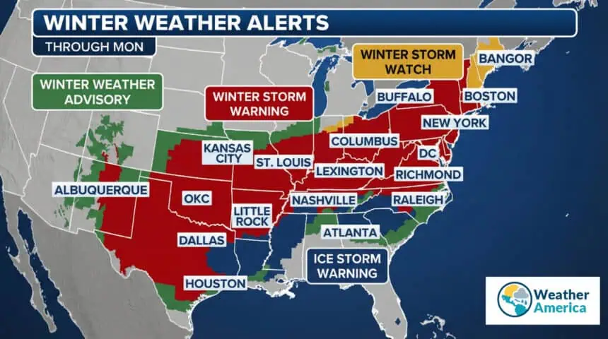
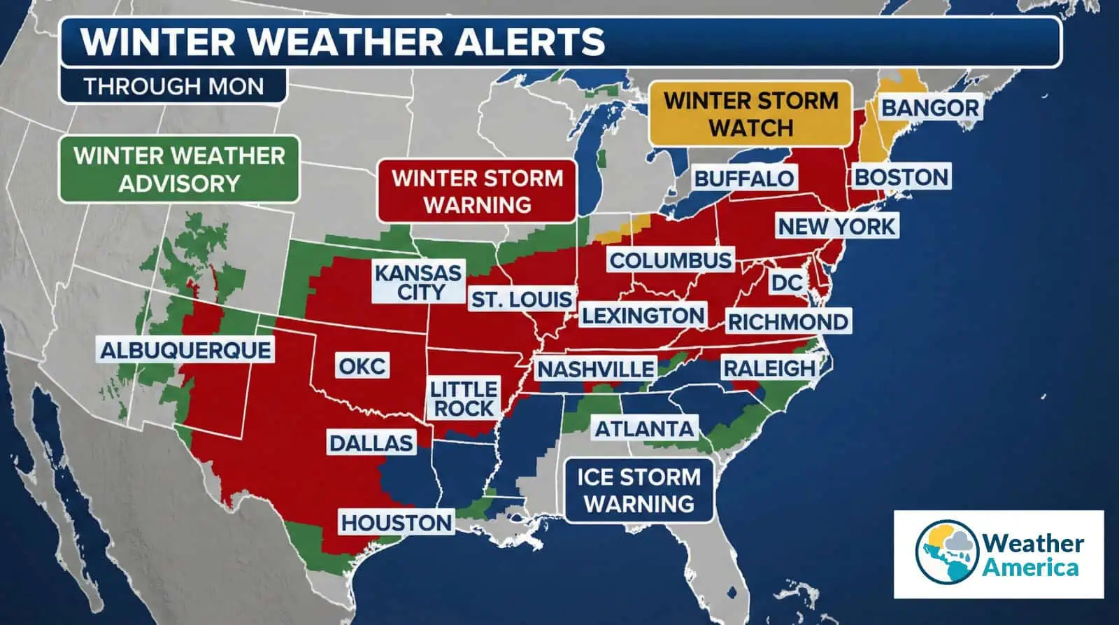
A widespread winter storm – named the “January 2026 U.S. Winter Storm” – is impacting much of the United States, bringing heavy snow, sleet, and freezing rain from the Southwest all the way to the Northeast Coast.
In the Northeast, including New York City and the coastal corridor, the storm began to make its presence felt during the night between January 24 and 25, but it is expected to intensify throughout Sunday, January 25, bringing heavy snowfall and extremely hazardous travel conditions. Significant snow accumulations, slippery roads, and major traffic disruptions are expected.
After the storm, an extreme cold wave is forecast to follow, prolonging dangerous conditions for several days. According to meteorologists, this is expected to be the most intense winter storm of the season in the Northeast, characterized by dry, powdery snow due to a high snow-to-liquid ratio of 15:1.
Weather forecast
Sunday, January 25: Heavy snow mixed with sleet throughout the day, with forecast accumulations of 4 to 6 inches (10 to 15 centimeters) in New York City, and up to 8 to 12 inches (20 to 30 centimeters) in interior parts of the Northeast. Highs around 23°F (-5°C), strong winds, and rapidly deteriorating road conditions. Snowfall will continue into Monday.
Monday, January 26: Continued snow and sleet, with total accumulations between 8 and 18 inches (20 to 45 centimeters) across many areas of the Northeast. After the storm system moves through, a period of intense cold is expected, with temperatures well below freezing and increased risk of black ice.
Following days: A trend toward gradual improvement, but persistent cold will remain. Light residual snow and ice advisories may still be in effect.
In total, over the next two weeks in New York City, five days of snowfall are forecast, with an overall accumulation of around 36 inches (91 centimeters).
Local alerts
Winter Storm Warning: In effect for New York City and the Tri-State area (New York, New Jersey, Connecticut) from 3:00 AM on January 25 through 6:00 PM on January 26. Associated risks: heavy snowfall (8 to 18 inches / 20 to 45 centimeters), sleet, and dangerous travel conditions. A state of emergency has been declared in New York and New Jersey.
Winter Weather Advisory: In effect for areas north of New York City, due to freezing fog and ice. Risk of black ice through the morning of January 25.
Snow Alert: Issued by the New York City Department of Sanitation, effective from 1:00 AM on January 25, to begin snow removal operations.
What national weather services are saying
National Weather Service (NWS/NOAA): Confirms a high-impact winter storm, with heavy snowfall and potentially catastrophic ice accumulations in some areas. Over 144 million people are currently under weather alerts. For the Northeast, snow totals between 12 and 18 inches (30 to 45 centimeters) are expected, followed by extremely cold air. Strongly advising the public to stay home.
AccuWeather: Describes the event as the most significant storm in recent years, with travel expected to be shut down from Sunday through Monday. For New York City, 6 to 12 inches (15 to 30 centimeters) of snow are forecast, with sleet and freezing rain lasting up to nine consecutive hours. Frigid temperatures and critical road conditions are expected.
The Weather Channel and local media: Confirm snow totals between 8 and 12 inches (20 to 30 centimeters) across the Tri-State area, with snow beginning Saturday night and peaking on Sunday. Coastal areas may see lower snow totals, but more freezing rain and sleet.
Affected areas in the U.S.
The storm is affecting a very large portion of the country, including:
Northeast (main impact zone): New York (including NYC), New Jersey, Pennsylvania, Connecticut, Massachusetts (including Boston), and parts of New England. The heaviest snow is expected in inland areas, while coastal regions may receive less snow but more sleet and ice.
Other impacted regions: The storm extends from the South (Oklahoma, Texas), across the Appalachians, the Midwest, and into New England. Areas including the Southern Plains, the Rockies, and the Gulf Coast are also affected, with tornado activity possible (though not in the Northeast).
Sources and Credits
- NOAA – National Weather Service
- ECMWF – European Centre for Medium-Range Weather Forecasts
- AccuWeather
- The Weather Channel
- New York City Department of Sanitation


