

June 2025 is shaping up to be unusually chilly across the Bay Area, with temperatures running between 1°F and 4°F (0.5°C to 2.2°C) below average throughout much of the region. While inland areas of the West bake under above-normal heat, the California coast is gripped by a reinforced marine layer and a persistent sea breeze that’s keeping things cool—very cool.
At Oakland International Airport, the average temperature so far this month has been a mere 59.9°F (15.5°C). That’s almost 3°F (1.7°C) below normal, and if the trend holds, June 2025 may go down as the coldest June since 1967 at that location. Similar patterns are playing out across the North Bay and South Bay, where temperatures have consistently lagged behind seasonal norms.
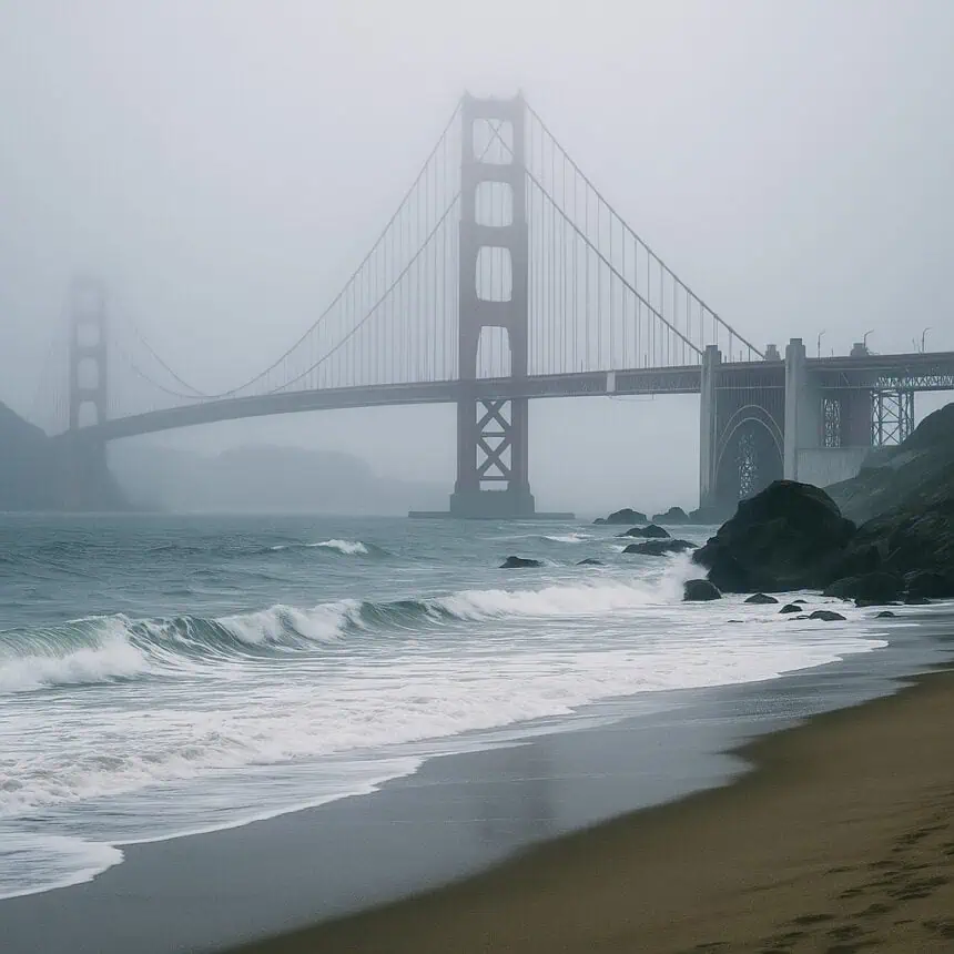
At San Francisco International Airport (SFO), temperatures haven’t surpassed 72°F (22.2°C) this month—an extraordinary statistic, considering that no previous June has ever failed to reach at least 75°F (23.9°C) since records began in 1946.
The reason for this unusual chill lies in what’s happening inland: as interior valleys heat up, rising hot air is replaced by dense, ocean-cooled air rushing in from the coast. This temperature differential acts like a natural air conditioner for coastal cities including San Francisco and Oakland, which are now experiencing stronger than usual sea breezes and a thicker-than-normal marine layer.
This setup has also brought with it an abundance of fog. According to recent data, SFO observed overcast skies at 8 a.m. on nearly half the days this month—a significant increase from the June average, when overcast skies are typically recorded only about one-third of the time.
Thursday’s forecast, however, will offer slightly sunnier skies, especially after midday. Still, temperatures will remain on the cool side, with highs near 60°F (15.5°C) at beaches and in the low to mid-70s (21°C to 23.8°C) along the bay shoreline. Inland valleys, such as those in the North Bay, East Bay, and South Bay, should push into the 80s (26.6°C to 31.1°C).
On Friday and Saturday, the interior valleys will briefly return to summer form, flirting with temperatures in the 90s (32.2°C to 35°C). But in San Francisco, the streak of sub-70°F (21.1°C) highs will likely continue, though just barely, with the city staying in the upper 60s (19.4°C to 20.5°C). Oakland could reach the mid-70s (23.8°C) by Friday afternoon, holding steady through Saturday.
San Francisco forecast
A drier air mass is pushing into the region, meaning quicker clearing than in recent days. Expect mostly sunny skies by afternoon, though northwest winds may gust up to 25 mph. Afternoon highs will vary by neighborhood: upper 50s to low 60s (14.4°C to 16.6°C) west of Twin Peaks, mid-60s (18.3°C) in Pacific Heights and North Beach, and upper 60s (20.5°C) in Mission District, SoMa, Bayview and Potrero Hill. Lows will dip to the low 50s (10°C to 11.1°C) with patchy fog overnight.
North Bay forecast
A wind shift from westerly to northwesterly will thin out morning clouds, allowing for warmer temperatures—especially in Santa Rosa, where highs may hit the upper 80s (31.6°C). Expect upper 70s to low 80s (25°C to 27.7°C) in Petaluma, San Rafael, and Vallejo, mid-80s (29.4°C) in Napa and Sonoma, and upper 80s to low 90s (31.6°C to 32.7°C) in Fairfield and Vacaville. Overnight lows will settle into the upper 40s to mid-50s (8.8°C to 12.7°C) with patchy coastal clouds.
East Bay forecast
Morning cloud cover will mainly stick to areas west of the Caldecott Tunnel, clearing by midday. Afternoon highs will rise to the upper 60s to low 70s (20.5°C to 21.6°C) in Richmond, Berkeley, Oakland, and Alameda. Hayward and Fremont will climb into the mid-70s (23.8°C), and Lamorinda will approach 80°F (26.6°C). The interior East Bay will surge into the mid-80s to 90°F (29.4°C to 32.2°C), especially in Antioch and Brentwood. Afternoon and evening winds may gust between 15 and 20 mph. Lows will be in the low to mid-50s (10°C to 12.7°C) under mostly clear skies.
Pacific Coast and Peninsula forecast
A foggy morning is expected, though a northwesterly breeze should clear skies by afternoon. Highs will reach the upper 50s to low 60s (14.4°C to 16.6°C) in Half Moon Bay, Pacifica, and Daly City, mid- to upper 60s (18.3°C to 19.4°C) in South San Francisco, San Bruno, Millbrae, and Burlingame, and low to mid-70s (21.1°C to 23.8°C) in San Mateo and Redwood City. Afternoon gusts could hit 25 mph, and lows will dip into the low to mid-50s (10°C to 12.7°C) under clear skies.
South Bay and Santa Cruz forecast
Thursday will be the warmest day this week for Santa Clara and Santa Cruz counties. San Jose will likely approach 80°F (26.6°C). Areas along the bay, including Palo Alto and Sunnyvale, will see mid- to upper 70s (23.8°C to 25°C), while Saratoga, Cupertino, and Morgan Hill should land in the mid-80s (29.4°C). Boulder Creek and Ben Lomond will range between the upper 70s and low 80s (25°C to 27.7°C), while Santa Cruz will sit around 70°F (21.1°C). Lows will settle in the mid-50s (12.7°C) inland and low 50s (10°C) along the Monterey Bay, with patchy fog expected.
Anthony Edwards, newsroom meteorologist
June 26, 2025 – The San Francisco Chronicle


