

Strong storms and potential travel disruptions expected on July 4
More than 72 million people are expected to travel across the United States during Independence Day week, according to the American Automobile Association (AAA). This year’s holiday, falling on a Friday, opens the door to an extended weekend, fueling the busiest July 4 travel period on record.
Out of the total, 60.6 million travelers will take to the roads, while 5.7 million will fly and nearly 4 million will rely on buses, trains, or other transportation. But as this massive movement unfolds, weather forecasts warn of potentially severe storms and heavy rainfall that could impact major highways and disrupt air travel.
FOX Weather’s Forecast Center reports that a cold front is expected to move from the Northern Plains toward the Southeast between Tuesday, July 2, and Thursday, July 4. As this system interacts with hot, humid air in the Southeast, it may trigger intense rain, thunderstorms, and even conditions that could give rise to a tropical system along the Atlantic Coast.
The affected region stretches from Louisiana to North Carolina, where persistent rain is expected through Thursday and the following weekend. Storms are also likely across southern Georgia, Florida, and parts of the Tennessee Valley.
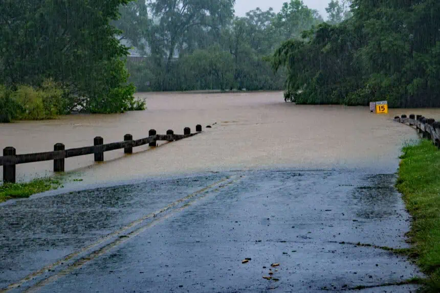
Urban flooding risk is especially high in areas where soils are already saturated. Poor drainage in coastal cities could worsen the situation. Although no system is currently well-defined, FOX Weather hasn’t ruled out the possibility of tropical development during the holiday stretch.
Heavy rain threatens Southeast, while Northeast remains mostly dry
The Northeast, Midwest, and Northern Plains are expected to stay mostly dry from Wednesday, July 3. However, Tuesday, July 2, could bring afternoon storms along the Interstate 95 corridor, affecting New York City, Washington D.C., and Philadelphia. These storms could lead to flight delays at major airports.
Key travel hubs like Atlanta, Orlando, and Miami may also see disruptions due to thunderstorms, especially on Tuesday and again on Thursday. The Hartsfield-Jackson Atlanta International Airport, the nation’s busiest, is among those forecast to face weather-related delays.
While there are no current tropical storm warnings, warm ocean waters and low-pressure zones off the Georgia and Carolina coasts are creating favorable conditions for cyclonic development. This is happening amid a slow start to the 2025 Atlantic hurricane season, which NOAA had predicted would be above average, with 17 to 25 named storms. So far, no major cyclones have formed.
Even if a storm doesn’t fully develop, the increased atmospheric moisture could still bring heavier rainfall throughout the Southeast.
Afternoon flight delays possible across major airports on July 2 and 4
FOX Weather highlights that afternoon storms on Tuesday could coincide with peak air traffic hours, especially for flights between the East Coast and Southeast. This may cause departure and arrival delays, as well as rerouted connections at airports like Charlotte, Raleigh-Durham, and Miami.
In contrast, areas west of the Rocky Mountains, including California, Nevada, Utah, and Arizona, will see dry conditions through the holiday. The Pacific Northwest, including Oregon and Washington, will also enjoy stable weather.
In the Midwest, cities such as Chicago, Indianapolis, and Cincinnati may experience light, scattered rain on Thursday, but no major storms are forecast. Precipitation in this region is expected to be intermittent and less intense.
The cold front lingering over the Southeast will continue to fuel rain through Sunday, July 7, across the central-southern states.
No extreme heat expected across the U.S.
Unlike recent years, extreme heat is not forecast for this holiday week. Temperatures will generally stay within seasonal averages, with highs ranging from 81°F to 91°F (27 °C to 33 °C) in the warmer regions.
Cooler conditions are expected in mountain areas and the Northeast, where daily highs will remain below 77°F (25 °C). While this weather may be ideal for outdoor activities in areas not hit by rain, it’s still important to follow local forecasts due to the dynamic nature of frontal systems.
Florida, Georgia, and the Carolinas are likely to bear the brunt of holiday-week rainfall, especially in coastal communities and regions vulnerable to flooding.


