

Florida in the crosshairs as rain and potential tropical system loom
FORT MYERS, Fla. – The Sunshine State is in for a stretch of very un-sunny weather this week as meteorologists track a developing low-pressure system that could soak parts of Florida with inches of rain and potentially grow into something tropical once it reaches the Gulf of Mexico.
What’s currently a weak non-tropical disturbance is expected to move off the Southeast U.S. coast, travel across northern Florida, and eventually drift into the Gulf later in the week. And with several days forecast over the warm waters of the Gulf and western Atlantic, the National Hurricane Center has flagged it as something worth watching.
As of now, the NHC gives the system just a low chance of becoming a tropical depression or storm within the next seven days, but has highlighted a wide swath of the Gulf Coast—from New Orleans through Florida and into the Atlantic—as an area under close observation.
In a weekend update, forecasters wrote, “Environmental conditions could become marginally conducive for the gradual development of this system by mid to late next week as the system moves generally westward across the Florida Peninsula and over the eastern and north-central portion of the Gulf. Regardless of development, heavy rainfall is possible over portions of the Florida Peninsula and southeast U.S. coast through mid to late next week.”
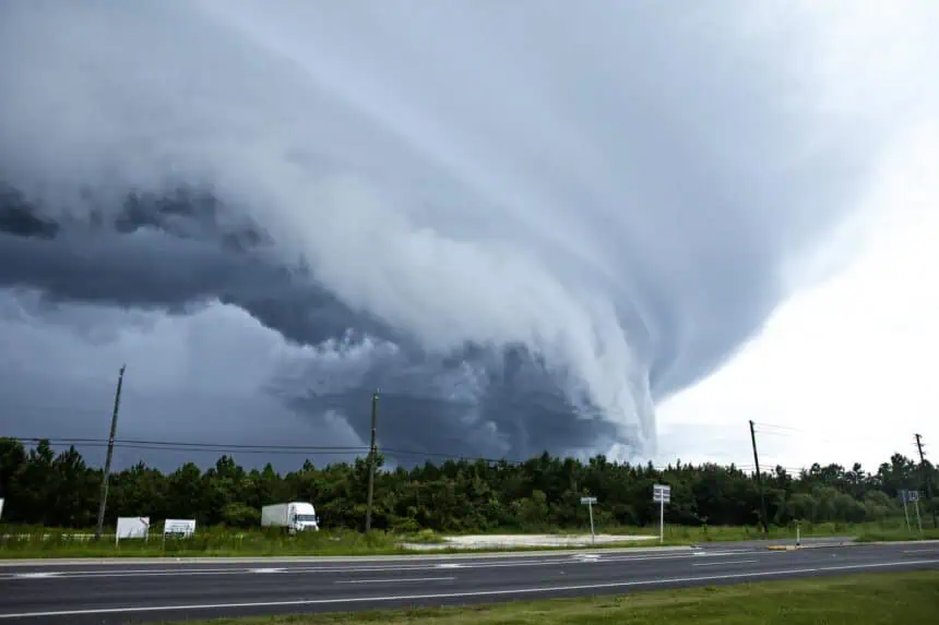
Heavy rain, flash flooding possible across Central and South Florida
Even if the system never earns a name, its impact will be felt. Central and South Florida are set for a multi-day soaking, with Monday likely bringing the most intense rainfall. Forecasts show 3 to 5 inches (76 to 127 mm) or more may fall across the area, especially south of the I-4 corridor, and some stronger thunderstorms could dump 1 to 3 inches per hour (25 to 76 mm), raising concerns for flash flooding, especially starting Sunday and continuing through the middle of the week.
The day-by-day placement of storms and the heaviest downpours will become clearer as the system evolves. But the message is already clear: expect a very wet few days ahead for much of the Florida Peninsula.
Tropical development? It’s possible — but far from certain
Later in the week, attention shifts to the Gulf of Mexico, where the system could try to organize into something more than just a rainmaker. So far, most forecast models don’t indicate a strong tropical cyclone forming, but some are starting to suggest a low-end system may develop, depending on how long it lingers over the warm Gulf waters.
FOX Weather meteorologist Michael Estime pointed out a “cinnamon bun swirl” on model charts — a sign of mid-level rotation — saying it could, emphasis on could, develop tropical characteristics by midweek if conditions line up just right.
That includes factors like wind shear, which can tear apart developing storms, and how much energy the system can pull from the warm ocean surface. For now, the setup is far from ideal — but it’s also not being ignored.
“There’s no credible threat at the moment,” the FOX Forecast Center said. “But the pattern is worth watching — and watch it, we will.”
Lightning strike injures three on St. Augustine Beach Pier
As stormy weather ramps up across Florida, it’s already led to dangerous conditions. On Saturday, a lightning strike hit the St. Augustine Beach Pier, injuring three people, according to St. Johns County Fire Rescue.
One person was critically injured and airlifted to a trauma center. Another was taken to a local hospital with less serious injuries. A third person declined to be transported after being evaluated.
The strike happened on the afternoon of July 12, just two days after a separate lightning incident claimed the lives of two teenagers on a fishing trip in Southeast Georgia. The St. Augustine pier was briefly closed following the strike but appeared to suffer only minor structural damage. Emergency officials haven’t said whether the victims had attempted to seek shelter before the lightning hit.


