
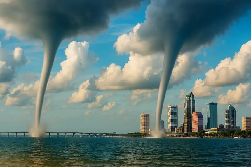
 Sunday evening, visitors and boaters around Tampa Bay and Fort De Soto Park were captivated by an extraordinary meteorological event—two waterspouts simultaneously spiraling above the bay, just east of Anna Maria Island.
Although waterspouts are a relatively common occurrence across Florida, the appearance of two at once remains a rare and dramatic sight, according to Stephen Shiveley, a meteorologist with the National Weather Service in Ruskin.
“It’s like seeing a double tornado in the Midwest,” said Shiveley. “That’s once-in-a-generation out there. Here, we might see a double waterspout once every few years—but it’s still rare.”
These marine twisters, which resemble tornadoes over water, form when cool downdrafts from thunderstorms interact with a sea breeze. As winds from various directions converge, they can start to rotate, forming a vertical column of spinning air. If a spout moves ashore, it may transform into a dangerous tornado.
On Sunday, however, both spouts remained over water and posed no threat. “That was the important thing,” added Shiveley. “No reports of impacts on boaters—nothing dangerous.”
The first waterspout was reported around 5:30 p.m., with the second emerging just five to ten minutes later. Both had dissipated by 6:00 p.m., according to the Ruskin forecast office. Nonetheless, photos and videos of the swirling phenomena spread rapidly across social media, capturing the awe of those fortunate enough to witness the rare twin display.
“These weren’t your typical pencil-thin waterspouts,” noted Shiveley. “They were pretty well-developed. That’s what made them stand out.”
What makes this event even more notable is that the current atmospheric conditions around Tampa Bay don’t favor frequent spout formation. Usually, morning hours and southwesterly or westerly winds are ideal for waterspouts. But lately, persistent easterly winds have been driving storms westward—making Sunday’s twin waterspouts even more unexpected.


