

Flash flooding slams New York City, breaks rainfall records, disrupts transit and flights
NEW YORK — Tuesday, July 15, 2025, 10:00 a.m. ET
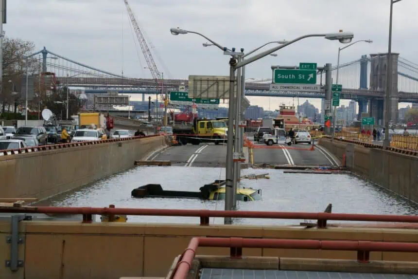
New York City woke up Tuesday morning still reeling from a powerful storm that brought torrential rain, flash floods, and widespread disruption across the region. Subway service was gradually returning to normal after water poured into stations, submerged platforms, and halted trains across multiple lines Monday night.
By dawn, the Metropolitan Transportation Authority had restored most subway, bus, and ferry operations, though delays and reroutes continued on several lines. NJ Transit and Amtrak also reported lingering service disruptions. Across Somerset and Middlesex Counties in New Jersey, entire sections of Route 22 and Route 28 remained closed in both directions as crews worked to clear debris and repair buckled pavement.
The National Weather Service confirmed that 2.64 inches (6.71 cm) of rain fell in Central Park on Monday, smashing the previous July 14 rainfall record of 1.47 inches, set back in 1908. Between 6:51 and 7:51 p.m., New York experienced its second wettest hour in recorded history, with 2.07 inches (5.26 cm) falling in just 60 minutes. Only Hurricane Ida in 2021 dropped more rain in a single hour.
Subways overwhelmed by sudden flooding
Subway riders captured dramatic video Monday evening as water gushed into stations from stairwells and ventilation grates. One clip showed a geyser of floodwater erupting inside the 28th Street station on the 1 train, forcing commuters to scramble onto seats to avoid the rising water.
According to Janno Lieber, chair of the M.T.A., the city’s sewer system is designed to handle just 1.75 inches (4.45 cm) of rain per hour — far below what fell during Monday’s downpour. The system simply couldn’t keep up.
“We pumped out millions of gallons overnight,” Lieber said. “And that’s becoming the new normal.”
Geophysicist Klaus Jacob, a professor emeritus at Columbia University, said the flooding goes beyond the M.T.A.’s control. “This is a drainage issue,” he noted. “Until the city and the M.T.A. address these problems together in a coordinated way, nothing will change.”
Airports, highways and neighborhoods hit hard
At Newark Liberty International Airport, dozens of flights were delayed or canceled. Service also slowed at JFK and LaGuardia, and while operations resumed Tuesday, travelers were advised to check with airlines for updates.
In New Jersey, neighborhoods like Scotch Plains bore the brunt of the storm. Streets were blanketed in brown sludge, rocks and tree limbs lay scattered, and tire tracks from stranded drivers marked suburban lawns. “The flood water was coming down like a river,” said Vincent Losavio, owner of John’s Meat Market, recalling similar events from the 1970s. “They keep building, but they don’t fix the flooding.”
Further south, flash flood warnings remained active early Tuesday across Virginia, Maryland, and Washington, D.C., where heavy rain was expected to continue through the morning. In Petersburg, Virginia, 50 residents were evacuated from an apartment complex after water swamped roads and damaged communications systems.
Ongoing risk of storms in the Mid-Atlantic
While skies were clearing over New York by midmorning, the slow-moving system responsible for Monday’s flooding was pushing into the Mid-Atlantic. The Weather Prediction Center issued a Level 2 out of 4 risk for excessive rainfall across Delaware, Maryland, Virginia, eastern West Virginia, western North Carolina, and northwestern South Carolina.
Forecasters said some areas could see rainfall rates exceeding 2 inches (5.08 cm) per hour. Flash flood watches remained in effect across much of the region.
The Bronx River crested at 3.7 feet (1.13 meters) early Tuesday before beginning to recede. In the New York City metro area, isolated showers and possible thunderstorms were still possible through the afternoon, especially near the coast.
Climate change challenges city infrastructure
Monday’s storm renewed scrutiny of New York’s aging infrastructure and its ability to cope with increasingly frequent extreme weather. Advocacy groups like Riders Alliance criticized the lack of investment in green infrastructure, which could help absorb excess rainwater and prevent subway flooding.
“This keeps happening,” said Danny Pearlstein, a Riders Alliance spokesperson. “The subway turns into a sewer system, while streets and homes flood. We need a serious plan.”
The M.T.A., for its part, says it’s seeking $6 billion in additional funding for coastal flood protection and stormwater improvements, including automated closures for subway vents, which currently must be shut manually before floods.
Looking ahead: more rain possible through Saturday
Although the storm system is weakening, forecasters warned the region isn’t in the clear. The Northeast and Mid-Atlantic remain under an active weather pattern for the rest of the week.
“The next threat targets New York into New England on Thursday,” said Joe Wegman, a meteorologist with the National Weather Service. “Then on Friday, it’s back to D.C., Maryland, Virginia, and southern Pennsylvania. That threat continues into Saturday.”


