

Bartholomew County, in the heart of Indiana, is now experiencing a dramatic shift in its climate reality — one that experts say could become the new normal. This spring season, the county has faced two confirmed EF-2 tornadoes, and the worst flood event in nearly two decades, placing it firmly in the path of more intense and frequent severe weather.
According to climate scientists, this pattern is not just an anomaly. It’s the result of a warming atmosphere that is turning areas like eastern Missouri, Arkansas, western Tennessee, Kentucky, northern Alabama, Mississippi, and now Indiana into new epicenters of tornado activity. As Professor Gabriel Filippelli from Indiana University states, “We are now within Tornado Alley.”
Tornadoes strike twice in one season after 50 years
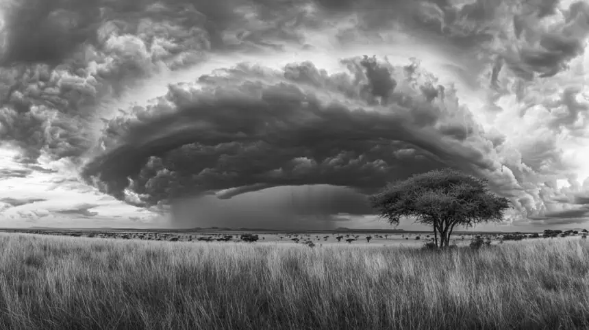
The most recent tornado, which hit on May 16, 2025, carved a 35-mile-long path of destruction, with a 200-yard-wide funnel ravaging the Grandview Lake area. This came just two months after a similar EF-2 tornado, boasting 112 mph winds and a width equivalent to 3.5 football fields, swept across southwest Bartholomew County, damaging farms, powerlines, and transmission towers.
Before 2025, the last time two tornadoes touched down in the county in a single year was in 1974, when a devastating storm spawned an EF-3 and a record-setting EF-4 twister in a single day.
Historic rainfall triggers major flooding
Between the two tornadoes, 7.5 inches (190.5 mm) of rainfall fell within 36 hours, causing the East Fork White River to crest at its third-highest level in 112 years. The only floods surpassing this one were in 2008 and 1913, underscoring the extreme nature of this spring’s weather.
Deputy Director Mike Snyder of Bartholomew County Emergency Management said, “Since 1999, I’ve never seen anything like this.”
Tornado Alley shifting east due to climate change
Traditionally confined to Texas, Oklahoma, and Kansas, Tornado Alley is now expanding. In the 1990s, Indiana recorded a median of 17 tornadoes per year. That number rose to 26 in the 2000s, then to 35 in the 2010s. So far this decade, the median stands at 33, and 2025 alone has already seen 44 tornadoes statewide — significantly above average.
Nationally, the U.S. typically records about 600 tornadoes by mid-May. This year, over 850 have already been confirmed, highlighting the widening and intensifying scope of severe storms.
Warming atmosphere driving extreme weather
Climate scientists point to a warmer, wetter atmosphere as the main driver of this trend. With global temperatures rising, more water vapor is entering the air, creating volatile conditions for intense storms. Low-pressure systems are also lingering longer, dumping inches of rain over the same regions for multiple consecutive days, which was the case in the April flooding event in Indiana.
As Filippelli explains, “Warmer air holds more water vapor. That water doesn’t just stay in the sky — it comes down hard. That’s why each storm is becoming more extreme.”
Floods and tornadoes to grow more intense by 2045
Climate projections suggest that extreme flooding could increase by another 15% over the next two decades, further intensifying risks for areas like Bartholomew County. Places previously considered relatively safe may soon find themselves in the crosshairs of destructive storms.
Twisters were once rare — not anymore
Historically, tornadoes were rare in Bartholomew County. Since 1950, only 21 confirmed tornadoes have been recorded — most of them moderate in intensity (EF-1 or EF-2). But that’s changing. Tornadoes are no longer limited to spring or summer; they’ve been documented as late as November and December.
As severe weather becomes more frequent and unpredictable, local authorities are bracing for what may be a long-term shift in climate behavior, though some still hope it’s a rough but isolated year.
“I hope this calms down,” said Snyder. “But we’re preparing for the worst. That’s all we can do.”


