

Scattered and isolated storms forecast across North and Central Georgia
A hazardous weather outlook issued by the National Weather Service (NWS) highlights the potential return of thunderstorms across North and Central Georgia beginning today, Monday, June 2, and continuing through Friday, June 6.
Today and tonight: Isolated thunderstorms possible
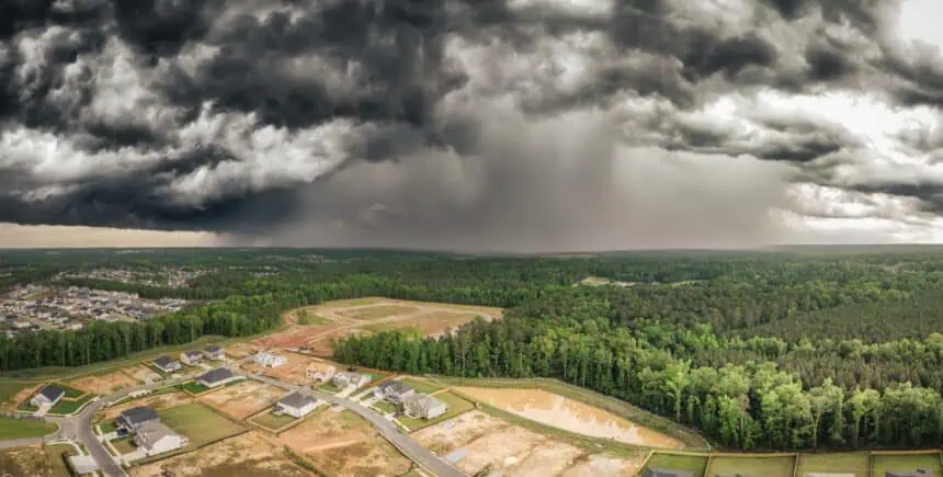
For Monday afternoon and evening, isolated thunderstorms could develop, especially across far North Georgia. These storms, while limited in coverage, could still bring intense rain, lightning, and gusty winds, even if affecting less than 20% of the area.
Through Friday: More widespread storm chances
From Tuesday through Friday, the weather remains unstable, with isolated to scattered thunderstorms expected across a broader portion of the region. Scattered storms indicate a 30% to 50% area coverage, meaning numerous storms could pop up without forming a continuous system. While no severe weather is currently expected, these storms may still pose localized hazards.
Counties under hazardous weather outlook
The advisory applies to a wide stretch of counties in North and Central Georgia, including:
Fulton, DeKalb, Gwinnett, Cobb, Bibb, Muscogee, Clarke, Hall, Forsyth, Bartow, Cherokee, Coweta, Fayette, Henry, Clayton, Rockdale, and over 90 others, covering urban centers and rural areas alike.
What do “isolated” and “scattered” storms mean?
Isolated thunderstorms refer to sporadic storm cells covering under 20% of the area. These events are localized, with wide gaps in between. Despite their rarity, they may still be intense, featuring strong downpours, lightning, or even small hail.
In contrast, scattered thunderstorms suggest numerous storms across 30% to 50% of the region, but still with gaps large enough that many residents may not see rain. These storms are not part of a larger storm line, but rather develop randomly over the area.
What this means for Georgia this week
While the probability of severe weather remains low, conditions are favorable for thunderstorm development nearly every day through Saturday. The pattern calls for warm, moist air masses and daytime heating, both of which contribute to instability in the atmosphere.
Stay updated on conditions in Atlanta, Athens, Macon, Rome, Augusta, and surrounding counties as the week progresses. Even non-severe storms can impact commuting, outdoor events, and localized flooding in urban zones.
About the National Weather Service
The National Weather Service, part of NOAA, provides timely forecasts and warnings across the United States, supporting public safety and economic stability. Their hazardous weather outlooks are meant to prepare communities for potential weather disruptions and help build a Weather-Ready Nation.
As of this morning, temperatures across Georgia are expected to reach highs in the upper 80s to low 90s °F (31–34 °C) with humidity levels increasing, which could fuel afternoon storm development.


