

A massive Saharan Air Layer to reach the Southeast
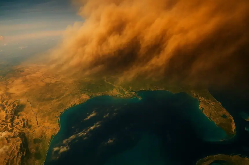
A colossal Saharan dust storm, described as a “grand-scale haboob”, is making its way across the Atlantic Ocean, heading toward the southeastern United States. The dense plume, originating from the Sahara Desert, is forecast to impact Texas and Florida starting Wednesday, potentially affecting conditions through Friday.
This extraordinary dust mass, roughly the size of the lower 48 states, has already traveled more than 4,000 miles (6,437 kilometers) across the ocean. Experts from NOAA and the Royal Meteorological Society emphasize the unique scale and reach of this event, fueled by powerful thunderstorm-driven microbursts in northern Africa.
What is a haboob and how it forms
Haboobs are intense dust storms formed by microbursts—strong, sinking air within thunderstorms that crashes to the surface and spreads out horizontally, lifting dust and sand high into the atmosphere. These airborne particles can rise up to 5,000 feet (1,524 meters) and spread out over 100 miles (161 kilometers) wide, carried by winds reaching 60 mph (96 km/h).
During the peak dust season—June through October—such plumes regularly emerge from Africa, with one new burst often developing every three to five days, according to hurricane scientist Jason Dunion.
What to expect along the Gulf Coast
As this Saharan Air Layer arrives, skies over Florida, Texas, and surrounding Gulf Coast states will likely turn hazy and reddish, due to sunlight scattering off the dust. Residents may notice a reduction in thunderstorm activity, increased heat, and dramatically hazier skies, especially on Thursday and Friday.
Joseph Prospero, aerosol expert at the University of Miami, noted that while the dust density will thin out over the Atlantic, its impact on sky color and clarity in the southeastern U.S. will be clearly visible.
Health concerns and environmental impact
The Copernicus Atmosphere Monitoring Service warns that surface-level dust can significantly worsen air quality, particularly for individuals with respiratory or cardiovascular conditions. Though most of this dust travels at high altitudes, some particulates may reach ground level, increasing levels of PM10 and PM2.5.
This dust also carries microorganisms, including bacteria and viruses, but researchers emphasize that these pose no unusual threat beyond normal environmental exposure, unless present in high concentrations.
Effects on tropical storms and weather patterns
The Saharan Air Layer, rich in dry air and mineral particles, plays a pivotal role in tropical storm dynamics. As this dry mass enters the tropical Atlantic, it can suppress cyclone formation by disrupting convection and depriving storms of moisture. However, areas on the edges of the dust plume can experience boosted storm activity, due to enhanced spin and instability.
In places like Puerto Rico, such a system can lead to hotter days, suppressed thunderstorms, and extreme haziness. According to Dunion, the dust dries out the atmosphere so thoroughly that cloud systems struggle to develop, leading to still, sweltering conditions.
Forecast for the coming days
The dust cloud is expected to reach Texas and Florida by Wednesday, bringing dry air, heat, and limited cloud formation. The atmospheric veil could linger until Friday, with visible effects across the Gulf of Mexico, including hazy sunsets, dry breezes, and a coated landscape.
Meteorologists are monitoring subsequent plumes already forming off the coast of West Africa, as Saharan dust continues its seasonal journey westward.


